 1 rok temu

„Pattern Locked” For „Non-Stop Storms” To Pepper Lower 48, „Snowmaggedon” Risks For Northeast
A series of winter storms is set to traverse the central and eastern United States through mid-February, bringing a mix of snow, ice, and rain. The next big round of winter precipitation could occur as early as next week.
Weather Channel’s Jim Cantore provided more color on the active storm pattern on X:
This pattern is locked and loaded right now. Non-stop storms will pepper the USA through mid-month and likely beyond.
Of course the devil is always in the details, but 3 impact events are likely Monday through Sunday of next week which will carry all hazards to some extent. Again not crippling, but impactful.
ECMWF below (out through the 18th) is locked into mean trough in the west with large-scale, Gulf moisture loving systems ejecting east. Still looking at potential for first upper end AR (atmospheric river) for southern CA next Thursday.
Cantore’s map, showing the active storm pattern, suggests that residents in the Mid-Atlantic and Northeast should be on alert for potential adverse weather conditions next week.
This pattern is locked and loaded right now. Non-stop storms will pepper the USA through mid-month and likely beyond.
Of course the devil is always in the details, but 3 impact events are likely Monday through Sunday of next week which will carry all hazards to some extent.… pic.twitter.com/zY80QG94ve
— Jim Cantore (@JimCantore) February 7, 2025
Several meteorologists on X have posted models showing the potential threat of „Snowmeggedon” in the Northeast through the midpoint of the month.
GFS 18z model update:
24″-36″ of snow expected in the next 10-days across the Northeast including NYC and Boston.
Are you not entertained? pic.twitter.com/njuldizvvt
— Ryan Maue (@RyanMaue) February 6, 2025
The theme of endless snowstorms continues on the 18z GFS…
If these models are even half correct, this will be a memorable February.
This map represents a running total out to the morning of Feb 20th and includes 6-7 different storms.
Snow lovers are going to be swimming like… pic.twitter.com/P7o8to1s4x
— Mark Margavage (@MeteoMark) February 6, 2025
Euro Snowmeggedon run for the northest, upcoming 15 days and period thru St Pattys day. Jackie Chiles sums it up pic.twitter.com/WjG47S8qSa
— The American Storm (@BigJoeBastardi) February 6, 2025
„It’s like déjà vu all over again!” Yogi Berra. Another round of Snow/Sleet and Freezing Rain (Ice) is likely again Saturday Afternoon into Saturday Night. And it still looks like the Snow Train is on track for Tuesday next week. Whew! Stay tuned… pic.twitter.com/Dg79FKzwNR
— Tony Pann (@TonyPannWBAL) February 6, 2025
On Tuesday…
Another Polar Vortex May „Penetrate Deep” Into Lower 48 By Mid-Month https://t.co/OQkabNu6ro
— zerohedge (@zerohedge) February 4, 2025
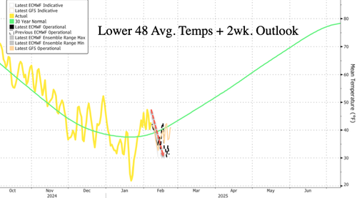
The latest Lower 48 average temperature forecast, combined with a two-week outlook, shows that the next round of cold will be less severe than last month’s.
Last Sunday, Punxsutawney Phil saw his shadow, signaling six more weeks of winter. Let’s hope this extreme cold comes to an end. Meanwhile, global warming alarmists in the far-left corporate media, along with Al Gore, the Democrats, and Greta, have been unusually quiet about the cold—or perhaps their USAID 'climate change’ funds have run dry.
Tyler Durden
Fri, 02/07/2025 – 17:20