 5 miesięcy temu

Hurricane Hunters Set To Probe Tropical Disturbance Near Georgia
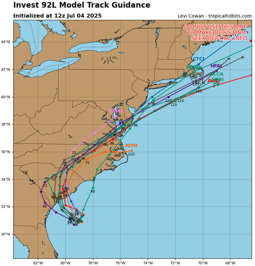
The 2025 Atlantic hurricane season began on a very quiet note, with little storm activity during June. However, as we shift into July, meteorologists on X are closely tracking a developing tropical system off Georgia’s east coast. The storm appears disorganized and lopsided at this time, but conditions are becoming more favorable for gradual strengthening. Spaghetti models show multiple forecast paths tracking up the U.S. East Coast, through parts of the Mid-Atlantic, and potentially over southern New Jersey—just barely missing New York City.
„We have „Invest 92L” lurking about 100 miles east of the Georgia coast. It’s been showing signs of development, with more thunderstorm activity blossoming. It’s unclear if a low-level center has formed, but the Hurricane Hunters will investigate soon,” weather app MyRadar wrote on X.
TROPICAL UPDATE: We have „Invest 92L” lurking about 100 miles east of the Georgia coast. It’s been showing signs of development, with more thunderstorm activity blossoming. It’s unclear if a low-level center has formed, but the Hurricane Hunters will investigate soon. pic.twitter.com/ZZR6iDjE1f
— MyRadar Weather (@MyRadarWX) July 4, 2025
MyRadar noted, „We see it’s roiling with convection, or shower/thunderstorm activity. That’s a sign of a healthy disturbance. But the system needs a center of circulation to better organize. Maybe there’s a low-level swirl buried somewhere in there… maybe not.”
We see it’s roiling with convection, or shower/thunderstorm activity. That’s a sign of a healthy disturbance.
But the system needs a center of circulation to better organize. Maybe there’s a low-level swirl buried somewhere in there… maybe not. pic.twitter.com/hpn1zuJLiu
— MyRadar Weather (@MyRadarWX) July 4, 2025
„The European model indicates a 70% chance that a tropical or subtropical depression forms,” MyRadar said.
The European model indicates a 70% chance that a tropical or subtropical depression forms.
It will have a short window of opportunity to develop, though, since it could move ashore sometime Saturday night or Sunday. pic.twitter.com/qXIpvxcyuj
— MyRadar Weather (@MyRadarWX) July 4, 2025
The latest spaghetti models, which display multiple forecast paths for the storm, indicate it may track up the East Coast, moving through the Mid-Atlantic with a more coastal approach, and narrowly miss New York City.
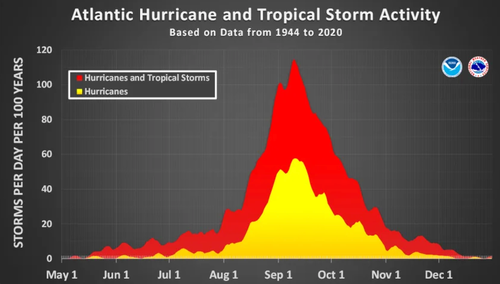
The months of August and September tend to be the most active for hurricane activity.
The next named storm, by the way, will be called Chantal.
Tyler Durden
Fri, 07/04/2025 – 17:30


![Antyrządowa demonstracja w Budapeszcie. Na czele główny rywal Viktora Orbana [ZDJĘCIA]](https://cdn.wiadomosci.onet.pl/1/Puik9lGaHR0cHM6Ly9vY2RuLmV1L3B1bHNjbXMvTURBXy84YWJkMWRjZi0yZWY1LTRmNTktOGMzMS01NDZjNDU3OGI2OTYuanBlZ5KVAwDNAd3NFO_NC8eTBc0JYM0GQN4AAqEwB6ExBA)