 10 miesięcy temu

China’s $167 Billion Tibetan Dam Alarms Scientists, Neighbors
Authored by Olivia Li via The Epoch Times (emphasis ours),
China has officially begun construction on a massive hydroelectric dam on the Yarlung Tsangpo River in Tibet, despite strong warnings from scientists about the region’s fragile ecosystem and complex geological conditions.
A Chinese hydrology expert has described the project as outright illegal, pointing out that it violates multiple international agreements and China’s environmental laws.
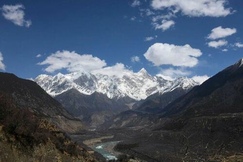
The estimated $167 billion project, formally known as the Motuo Hydropower Station, is situated on the eastern edge of the Tibetan Plateau. It is set to become the world’s largest hydroelectric dam, with a projected annual output of 300 billion kilowatt-hours.
On July 19, Chinese Premier Li Qiang attended the groundbreaking ceremony, referring to it as the “project of the century,” according to Chinese state media.
The Yarlung Tsangpo River, also known as the Brahmaputra in India and the Jamuna in Bangladesh, is the highest major river on Earth, with an average elevation of approximately 4,000 meters (13,123 feet).
The dam will harness energy from the river’s dramatic Great Bend, where it takes a sharp U-turn and plunges nearly 2,000 meters (about 6,562 feet) before flowing into India.
After decades of planning, Chinese authorities approved the project in December 2024, reigniting serious concerns over its feasibility, safety, and environmental impact.
Geological Risks
Some experts in India and Bangladesh, where millions depend on the river for irrigation, drinking water, and flood control, have expressed concerns about the dam’s potential safety risks and the negative impact of disrupting the river’s flow.
Shortly after China’s announcement last year, Y. Nithiyanandam, head of the Geospatial Research Program at the Takshashila Institution in Bengaluru, voiced strong opposition, citing both geological instability and the dam’s potential transboundary effects.
“The region proposed for dam construction is highly susceptible to landslides and is located on a geological fault line that intersects the Yarlung Zangbo,” Nithiyanandam said, as quoted by digital newspaper The Pulse.
“Planning a dam of this magnitude in such complex terrain poses significant risks to downstream regions of India and Bangladesh, especially in the event of a mishap or if there is an alteration in the water flow.”
He further pointed to the January 2025 earthquake in Tibet, which claimed at least 126 lives, as a stark reminder of the dangers of building mega infrastructure in seismically active zones.
This region has long been known for intense seismic and geological activity.
In April 2000, a massive landslide in Yigong township, Bomi county, southeastern Tibet, created a natural dam. Two months later, the lake breached, triggering flooding that affected millions of people.
On Aug. 15, 1950, a magnitude 8.6 earthquake struck near the river bend, causing widespread destruction in both China and India. It remains the strongest continental earthquake ever recorded since modern seismic data became available in China.
A Feasibility Study
Chinese geologist Yang Yong, director of the Hengduan Mountain Research Institute, has long opposed large-scale hydropower development in the region.
In 2014, he published a series of articles explaining why the region is unsuitable for large hydropower projects. Yang pointed out that the Tibetan Plateau, the source of major rivers in Asia, relies primarily on glacier meltwater for river replenishment, making the water supply unpredictable due to weak precipitation and significant seasonal variability.
As a result, he said, hydropower plants would face low operational reliability, poor energy output, and serious risks from freezing and river blockages during winter.
Additionally, he warned that the region’s complex geological conditions make it nearly impossible to construct effective regulating reservoirs, which are crucial for adjusting output and maintaining operational stability.
An ‘Ecological Treasure’ at Risk
Beyond geological concerns, environmentalists warn that the Motuo Hydropower Station poses a severe threat to one of the planet’s most unique and biodiverse ecosystems.
Wang Weiluo, a hydrologist based in Germany, has been a vocal critic of the project since China first began considering it in 2020.
The area is “a unique ecological treasure that must be preserved with the utmost care,” he recently told the Chinese-language edition of The Epoch Times.
The project site lies within the Yarlung Tsangpo Grand Canyon—the longest and deepest canyon in the world. Rich in endemic and endangered species, the canyon is renowned for its biodiversity and fragile ecosystem.
In 2021, a team of Chinese researchers led by Lu Zhi, a professor at Peking University’s School of Life Sciences, called for the canyon area to be designated as a national park. In an article published in the journal Nature, they stressed the urgent need to protect the area’s ecological environment from threats posed by tourism and infrastructure projects.
“The environmental consequences of damming the Yarlung Tsangpo would far exceed those of the Three Gorges Dam,” Wang told The Epoch Times, emphasizing that the region’s biodiversity is irreplaceable and must be conscientiously protected.
One of the major issues with the Yarlung Tsangpo hydropower project, according to Wang, is that it is illegal—not just under international conventions and treaties but also under China’s laws.
The canyon area is currently designated as a national-level nature reserve. Under Article 32 of China’s Regulations on Nature Reserves, “no production facilities may be constructed within the core or buffer zones of a nature reserve.”
Wang told The Epoch Times that the project also violates multiple international agreements, such as the 1992 Convention on Biological Diversity, the 1972 UNESCO World Heritage Convention, and the 2003 UNESCO Declaration Concerning the Intentional Destruction of Cultural Heritage.
Chinese state media have touted the hydropower project as designed to divert 60 billion cubic meters of water from upstream of the dam site into underground tunnels for power generation, while maintaining a total downstream flow of 140 billion cubic meters to avoid disputes over water resources for downstream populations.
However, according to Wang’s calculations, this scenario would cause a stretch of the river downstream to run completely dry—“not a single drop of water,” he said. Water would only reappear where the Parlung Tsangpo River merges with the Yarlung Tsangpo north of the Great Bend, he said. This depleted section, Wang warned, would lead to the collapse of the river’s aquatic ecosystem.
“This is the ecological disaster that the Motuo Hydropower Station would bring,” he said.
Tyler Durden
Sun, 07/27/2025 – 16:20